


The European Terrestrial Reference System 1989 (ETRS89)
| Task: Realisation of a Europe-wide, standardised spatial reference. |
|
|
History: In the geodetic datum of the ITRF, sets of coordinates with movement vectors are calculated at the beginning of every year (e.g. 1989.0) for approx. 180 stations distributed world wide. Output elements for the European datum ETRS89 are the derived ITRF coordinates of the European ITRF stations for the beginning of the year 1989 (1989.0). These coordinates define the ETRS89 which is thus invariant to occurring changes, e.g. Atlantic drift rates in the ITRF coordinates of the European stations. |
Coordinate axes of ETRS89 |
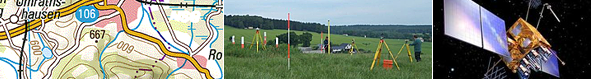
| Further points in Europe have been determined using VLBI (Very Long Baseline Interferometry) measurements which have been integrated in the ETR89. In order to be able to be used for practical work, the wide-meshed network thus created for Europe has been hierarchically further densified at the European level by the EUREF-GPS measurement campaigns, at the national level by the DREF-GPS campaign and at the federal States level by so-called C-Net GPS campaigns. | |
|
The ellipsoid of the Geodetic Reference System 1980 (GRS80) is used for the calculation of geographic coordinates and (ellipsoid) heights in ETRS89. In 1991, the AdV decided to implement this reference system for the surveying and mapping and real estate cadastre areas. |
|
| Publications: Boucher, C., Altamimi, Z., 1992 Terrestrial Reference System and its first realizations; Veröffentlichung der Bayerischen Kommission für die internationale Erdmessung , Astronomisch-Geodätische Arbeiten. Heft Nr.52, 1992 p. 205-213. Moritz, H. 1980. Geodetic Reference System 1980 (GRS80). Bulletin Géodésique vol.54. |
|