


Central Office for SAPOS
Central Office for Satellite Positining Service of the Offical German Surveying and Mapping (ZSS)
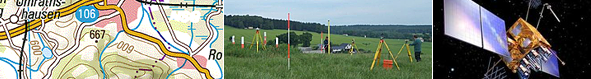
 SAPOS® - Precise Positining in Location and Height
SAPOS® is your solution if you wish to coordinate information, navigate vehicles or geo-reference thematic data. Makling use of modern technology you easliy and comfortable receive the spatial reference for your data quickly and precisely, based upon the Satellite Navigation Sys´tem GPS, GLONASS and in futurwe Galileo. The following services, tailored to your individual requirements, are offered in different accuraca levels and applications in both realtime and postproccesing:
|
|
HEPS |
GPPS |
|---|---|---|
| Procedure | Real time | Postprocessing |
| Accuracy - position | 0,01 - 0,02 m | < 0,01 m |
| Accuracy - height | 0,02 - 0,03 m | 0,01 - 0,02 m |
| Transmission technique | Ntrip over Internet (GRPS, UMTS, LTE), GSM | Internet (Web-Server) |
| Clocking unit | 1 sec | > 1 sec |
| Unit | 1 min | 1 min |
| SAPOS®-fee per unit | 0,10 EUR | 0,20 EUR |
| Standard, Format | RTCM 3, RTCM 2.3 | RINEX 2.1 |
For more informations on the SAPOS®-Services and offers of the Central Office SAPOS®, please visit the website www.Zentrale-Stelle-SAPOS.de.
Landesamt für Geoinformationen und Landesvermessung Niedersachsen (LGLN)
Landesvermessung und Geobasisinformation Niedersachsen - Landesbetrieb (LGN)
Podbielskistraße 331
30659 Hannover
E-Mail: sapos-zentrale-stelle@lgln.niedersachsen.de
Telefon: + 49 (0)551 64609-222
Fax: +49 (0)551 64609-168