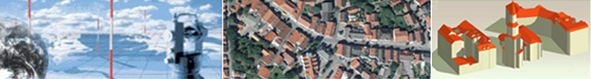

The official 3D Building Model of Germany in Level of Detail 2 (LoD2-DE)
In the database of the 3D Building Model with the "Level of Detail 2" (LoD2-DE) all above-ground buildings and structures including standardized roof types according to the actual ridge courses are represented. The building footprint is usually derived from the official real estate map and is therefore location accurate. The database currently includes around 58 million buildings.The "Central Office House Coordinates and Building Polygons" (ZSHH), set up at the Agency for Digitisation, High-Speed Internet and Surveying in Bavaria, merges and provides the LoD2-DE of the Surveying Administrations of the Laender based on standardized fee and license models in the nationwide standardized CityGML format. The ZSHH currently provides an updated LoD2-DE database once a year.
The 3D Building Model documents their individual added value e.g. in the following areas:
- Planning and analysis processes in the field of photovoltaics, solar energy – orientations, potentials
- Creation of derived products, e.g. volume calculation (insured amounts, energy demand), number of full floors, shadow casting scenarios
- Basis for 3D visualizations
- Model and network planning in mobile radio communications
- Implementation of the EU Environmental Noise Directive
- Styles of roofs, ridge courses
- Solar cadastres
- Emergency management
The content is based on the Product and Quality Standard for 3D Building Models of the AdV.
The data essentially includes the following:
- Object fields of „buildings“ and „structures“ as defined in ALKIS (Authoritative Real Estate Cadastre Information System, definition according to ALKIS-OK), if recorded – underground buildings are not included.
- The coordinates are provided by default as ETRS89/UTM coordinates in zone 32 and zone 33 (because of the image distortion only the eastern Laender can be delivered in zone 33).
- Attributes:
- Height of the building as the difference in meters between the highest and lowest point of reference of the building
- Object identifier
- Building function
- Indications of quality (metadata, e.g. source of the roof height, location, …)
- Official municipality key
- Generalized roof type
- Name (if recorded)
- Location description (if recorded)
- TerrainIntersection (if recorded)
All essential information at a glance:
| Number of LoD2-DE | about 58 million nationwide |
| Data format | CityGML |
| Updates | once per year |
| Reference system | ETRS89/UTM, Zone 32 or 33 |
| Delivery units | nationwide |
A data format description can be found here.
Contact
Bavarian Agency for Digitisation, High-Speed Internet and Surveying
Tel.: +49 (0)89 2129-1299
zshh@ldbv.bayern.de