

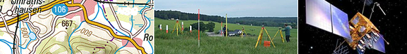


SAPOS - the German satellite positioning service
The surveying authorities of the States of the Federal Republic of Germany (AdV) operate the SAPOS® satellite positioning service as a joint project and thus provide the current, official wide area spatial reference for everyone using modern technology. Thus, the user can save a temporary reference station and solve his spatial reference tasks more economically and efficiently. This is considered as an infrastructure basic provision and as part of the legal remit of the German state survey.
SAPOS has set up a permanently operated, multifunctional differential GNSS service. The system is based on a network of approx. 270 GNSS reference stations which are operated by the AdV. SAPOS correction values are available to the user in real-time and for post-processing. This service is widely available with high reliability and comprises three service areas with different properties and accuracies:
SAPOS®-EPS real-time positioning service
SAPOS®-HEPS high precision real-time positioning service
SAPOS®-GPPS geodetic post-processing positioning service
Further information (in German) to SAPOS® you find under www.sapos.de and www.zentrale-stelle-sapos.de.
Kontakt zur AdV-Geschäftsstelle
PDF-presentation “SAPOS” in English for download
Further reading (in German), free of charge PDF download:
Riecken, J.; Kurtenbach, E.: Der Satellitenpositionierungsdienst der deutschen Landesvermessung – SAPOS, zfv 5/2017, S. 293-300
link: http://geodaesie.info/zfv/heftbeitrag/6970
Jahn, C.-H., Riecken, J., Trautvetter, C., Freitag, M., Kurtenbach, E., Fabian, G., Dick, H.-G.,: „Quo vadis SAPOS? – Zukünftige Entwicklungen des Positionierungsdienstes der Landesvermessung“, in DVW-Schriftenreihe Bd. 87
link: http://geodaesie.info/sr/gnss-2017-kompetenz-fuer-die-zukunft/6245/80