


Central Office for Geotopography (ZSGT)
The Central Office for Geotopography (ZSGT) centrally provides digital cross-border spatial base data of the Federal Republic of Germany to economy, science, administration and all citizens on behalf of the Laender of the Federal Republic of Germany. The ZSGT is operated at the Service Centre of the Federal Agency for Cartography and Geodesy in Leipzig.
Users profit from a comprehensive spectrum of Internet services that conveniently can be tied into custom applications and that continuously access the most current spatial base data. Furthermore, the traditional provision of data in spatial and content selections, various georeferencings and data exchange formats is possible.
The data of the Laender are merged and technically harmonized at the DLZ. Formal completeness and format consistency are also checked. Accompanying metadata and overviews of topicality provide the user transparently with information on the quality of the spatial data.
In the following, you get an overview of the various available spatial data.
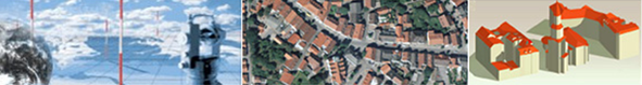
 Digital Landscape Models
The Germany-wide Digital Basic Landscape Model (Basis-DLM) of the surveying authorities of the Laender offers you a unique information density. It reflects the real copy of the landscape neutrally and in detail with a maximum claim to completeness.
You can select from up to 160 different feature types and the corresponding attributes. Based on this basic information, you can analyze, plan and decide individually. You may rely on the high geometrical accuracy as well as on highest possible topicality, which is guaranteed by a dense regional network of recording and communicating institutions.
Further product information you may find here:
Product information Digital Basic-Landscape Model (Basis-DLM)
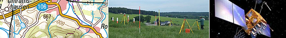
 Digital Topographic Maps
For decades, the official Topographic Maps are known for their unique richness of detail. Commercial enterprises, professional planning offices and hikers use them alike. The maps impress with a cartographic representation that meets the highest demands on clarity, readability and precision. They give a quick overview of building structure, land use and terrain forms. Residential and industrial areas are as easily and clearly to identify as type and density of the road and path network.
The Digital Topographic Maps are available in various scales between 1:25 000 and 1:100 000. Benefit from this diversity and use the depth of information and contents of the single map scales responding to your needs for small-scale regional planning or the set-up of a nation-wide distribution network!
Further product information you may find here:
Product information Digital Topographic Map 1:25 000 (DTK25)
Product information Digital Topographic Map 1:50 000 (DTK50)
Product information Digital Topographic Map 1:100 000 (DTK100)
 Digital Orthophotos
There is no more complete form of representing a landscape, than by a photo. Today, innumerable Internet services benefit from the positive qualities of digital aerial images and from what they trigger in the viewer.
Digital Orthophotos, however, do not only open up purely visual possibilities for evaluation. Due to their uniform scale, they have many characteristic qualities of a classic map. So it is possible to measure distances and calculate areas. Additionally, the Orthophotos can be supplemented by further selected contents, e.g. from Digital Landscape Models. By integrating street names and administrative boundaries combined with custom planning information, Orthophotos become an indispensable presentation medium with a high recognition value.
Further product information you may find here:
Product information Digital Orthophotos DOP20 / DOP40
 Digital Terrain Models
Digital Terrain Models (DGMs) in diverse quality levels are being established as part of the ATKIS project carried out by the German Land survey institutions to uniformly describe the relief of the territory of the Federal Republic of Germany.
The following quality levels are available:
- Digital Terrain Model with 5 m grid width (DGM5)
- Digital Terrain Model with 10 m grid width (DGM10)
- Digital Terrain Model with 25 m grid width (DGM25)
- Digital Terrain Model with 50 m grid width (DGM50)
These models describe the terrain forms of the Earth's surface by means of a point quantity arranged in a regular grid and georeferenced to planimetry and altimetry.
Further product information you may find here:
Product information Digital Terrain Model with 10 m grid width (DGM10)
Product information Digital Terrain Model with 25 m grid width (DGM25)
Product information Digital Terrain Model with 50 m grid width (DGM50)
Joint services of Federal Government and Laender
WebAtlasDE
The WebAtlasDE is an Internet map service developed jointly by the Federal Government and the Laender and provided by the Federal Agency for Cartography and Geodesy (BKG). Based on official spatial base data, it shows an attractive, nationwide uniform map representation in zoom levels from the single building to an overview of whole Germany. Its efficient realization based on international standards and its modern cartographic design support diverse application fields.
Base data for the WebAtlasDE are the Basic Landscape Model, house coordinates and building polygons of the Laender as well as the Digital Landscape Models 1:250,000 and 1:1,000,000, maintained at the BKG.
 Geocoding Service
Geocoding is the assigning of a spatial position information (coordinate) to a dataset or a feature. The web service of Federal Government and Laender operated at the Federal Agency for Cartography and Geodesy (BKG) is based on international standards and supports the geocoding of whole registers as well as of single addresses – optimized for interactive address search.
Users can send their data online to the service and get back georeferenced address data. The coordinates are entered into a register of the user by means of a specific user application.
Further information about all available data and services you get at www.geodatenzentrum.de www.geodatenzentrum.de and at the following address:
Federal Agency for Cartography and Geodesy
Service Centre
Central Office for Geotopographie
Karl-Rothe-Straße 10-14
D-04105 Leipzig
E-Mail: dlz@bkg.bund.de
Telefon: + 49 (0)341 5634-333
Fax: +49 (0)341 5634-415
Our staff will be pleased to advise you!